
City adds north end of island to aerial imaging project
May 20, 2021
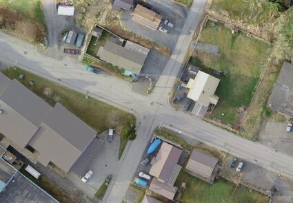
Photo courtesy City & Borough of Wrangell
The city's aerial imaging project includes photography with the clearest images yet of the community from above. This photograph shows the intersection St. Michaels and Reid streets, with the high school in the lower left.
For not much more money - less than $10,000 - the city is able to add 411 acres at the north end of the island to an aerial imaging project that already covers 957 acres of downtown, Wrangell's water reservoirs, and land south and east of Heritage Harbor.
It has been almost 20 years since aerial photography of the community. In addition, the project includes LiDAR, an airborne pulsed laser signal that "sees," measures and produces detailed three-dimensional images of the terrain, ground cover and surface characteristics.
LiDAR, which stands for Light Detection and Ranging, is used in right...
For access to this article please
sign in or
subscribe.


Reader Comments(0)